Southwest New Mexico
First Steps in the First Wilderness Part 8: December
Monday, December 16th, 2019: Hikes, Holt, Mogollon Mountains, Southwest New Mexico.

There were snowstorms in the mountains over Thanksgiving, and more a week later. As the weather warmed after that, I discovered the creeks were too flooded with snowmelt to cross in many places, and the snow too deep and crusty to trudge uphill in. But the weather stayed warm and I was hoping I could get in one more hike up my favorite trail before more snow made it impassable.
The creek in the canyon bottom turned out to be very loud, but crossable. The bigger problem was all the new logs blocking the trail, fire-killed snags brought down as melting snow softened the soil. But I climbed over and around them.
Finally, nearing the crest, I encountered snow up to knee deep, but not enough to stop me. I was motivated by the views!

New deadfall across the trail, brought down as snowmelt softened the soil

On the switchbacks

Nearing the crest

It keeps getting deeper, and unstable – sometimes there’s a firm crust, other times you sink through to your knees
It was windy up there, so I didn’t linger. But for the third Sunday in a row, I was passed by a golden eagle – this time carrying what appeared to be a stick.
The five-mile descent was made difficult by an unexplained searing pain in my ankle. I’d started the hike earlier than usual, but nearing the winter solstice the days are short, and the pain slowed me down, so I expected to finish the hike in the dark.
Luckily I had my new headlamp to help me over the loose rock in the last half-mile of trail!

Last light beside the creek

Using the new headlamp

Evening star (Venus) in the west
No Comments
Two Eagle Day
Monday, January 6th, 2020: Burro Mountains, Hikes, Southwest New Mexico.
Deep snow on the mountains means I can’t hike my usual trails that go higher than 8,000′. I needed to find something at lower elevation. I decided to hike a forest road that starts at 6,000′ and climbs to an 8,000′ peak. I’ve climbed this peak many times from the opposite direction, which is much easier, but I couldn’t reach that end because of snow on the road.
This road quickly climbs several hundred feet to provide a view to the west. Looking up toward the peak I was approaching, I saw two golden eagles. This is the fifth weekend in a row that I’ve seen golden eagles!
Midway up the road reaches the ponderosa pine forest, and traverses the shallow valley of a stream, which is dry most of the year. Then the road starts climbing again, and is very steep the rest of the way.
Unfortunately the peak is covered with towers which provide our local TV, radio, and cell phone service.

To the west, snow covers the Pinaleno range in Arizona

Golden eagles

Steep climb

Last stretch leading to peak

To the southwest, the Chiricahuas

Panorama east
A hundred yards below the peak I encountered a big pickup truck with a young couple, coming up the road in the snow. They were the first people to drive up this road since the last snow. It’s barely driveable with 4WD.
We smiled and waved at each other, and hours later, near the bottom, they passed me on their way down. They were probably thinking, what a crazy guy to walk up this road instead of driving. I was thinking, what lazy people to drive up the road instead of walking.
Near the bottom, I turned back and saw the moon rising in the east.
No Comments
Little One
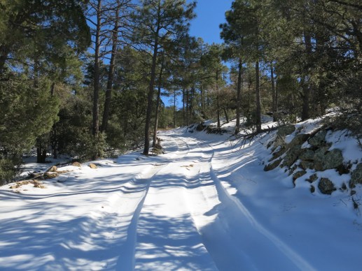
Monday, January 13th, 2020: Hikes, Holt, Mogollon Mountains, Southwest New Mexico.
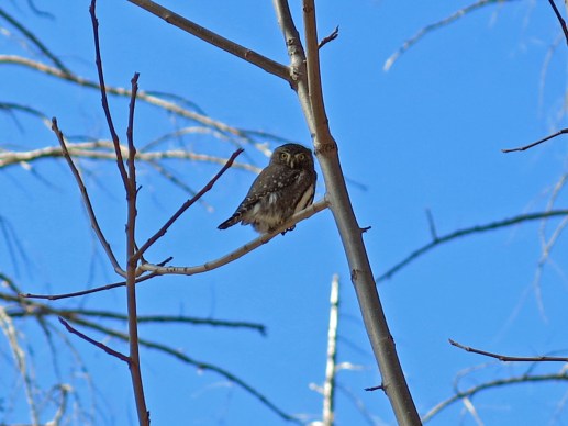
The snow would only allow me to climb 80 percent of the way to the crest. But my day was made early as I came upon a Northern pygmy owl in the canyon bottom.

Northern pygmy owl

As high as the snow will let me go today

On the way down

Fruit of smooth sumac
No Comments
First Steps in the First Wilderness Part 9: January
Monday, January 20th, 2020: Hikes, Mogollon Mountains, Southwest New Mexico, Whitewater.

Above 8,000′, the snow was too deep to hike my favorite trails. And my 4wd was in the shop so I couldn’t drive muddy and/or icy roads to most of the other trailheads. After trying and failing to drive an unfamiliar backroad an hour from home, I was forced to fall back on a low-elevation trail into a popular canyon, a trail much shorter than I usually hike on a Sunday.
But it was worth it! I’d forgotten how beautiful the landscape is from this trail. The side canyons had rushing water, and the main creek was raging with snowmelt.

Approaching the snowcovered crest from the southeast

Ascending the first ridge above the canyon, looking back down at the canyon’s mouth

Looking up-canyon toward the snowcovered crest of the range

Crossing the first side canyon, which is normally dry

Discovering a “window rock” above the trail that I hadn’t noticed before

Cliff overhanging the canyon bottom

Volcanic breccia along the trail

Down in the canyon, looking up to its head

This small stretch of canyon is perpetually in the shade and retains freezing temps despite its low elevation

A new patch of the very destructive invasive plant Vinca, commonly known as periwinkle

Vinca smother all native vegetation

Pinnacles above the trail

The creek is about 15′ wide, carrying up to 8 times its normal volume

This “weeping” bunchgrass is one of my favorites

In patches of sun I was swarmed by clouds of leafhoppers that were massing on trailside oak shrubs

Graphocephala atropunctata, commonly know as the blue-green sharpshooter
After reaching the canyon bottom trail, working my way up along the raging creek, and fighting my way through clouds of leafhoppers that rose from trailside shrubs in the few sunny patches, I was finally stopped when the trail ended in an impassable rockslide. None of these trails has been maintained since the 2012 wildfire.

A giant sycamore leaning over the creek

A stretch of trail reinforced with flatrocks by long-ago volunteers

Vinca smothering two yucca

I climbed above the trail to the window rock for some closeups

I love the strata in this cliff

At center, in the far distance, the Mogollon Rim of Arizona can just barely be seen behind the peak of the Blue Range
No Comments
Hiking in Place
Monday, April 27th, 2020: Hikes, Nature, Southwest New Mexico, Various, Wildfire.

Like every crisis in our alienated society, COVID-19 has revealed more of the social and ecological failures we live in everyday denial of. It was clear from the beginning that the virus became a pandemic due to our technologically-enhanced national and global mobility. The more people venture outside their local communities, the farther the virus spreads. But raised as individualists in our European-derived culture, we take our mobility for granted and resist any constraints on our ability to travel.
My weekend hikes have evolved to encompass a radius of a hundred miles from my home, but as the virus spread and voluntary travel restrictions were imposed, it became clear that the farthest of those hikes would take me out of my local service area and expose me to risk of interacting with people in other communities. So I dropped those destinations and stuck to hikes which, if anything went wrong, would limit my exposure to services and people in my local community.
I’m lucky to live in a small town which supports a vast rural region. For city people, the restrictions are much more limiting. Your local “community” is typically a tiny, densely populated enclave of strangers, completely surrounded by similar enclaves. If you want to get out into “nature” – a nearby park landscaped with non-native plants and infested with invasive species – you enter into competition with thousands of people from neighboring communities. Hence many city parks have been closed. And if you travel outside your enclave, you’re immediately at risk of spreading the virus. But that’s the price you pay for living in a city – an unhealthy environment at the best of times.
Thus one of the most profound failings of our alienated way of life is exposed – the meaninglessness of “communities” to modern, urbanized people. City people are lucky if they even know their next-door neighbors. The idea of living in a neighborhood has only intangible value to them. In a crisis, it’s every man for himself. He can’t be bothered to care about the health of the thousands of strangers surrounding him. He just desperately needs to “get out.”
Early spring is a transitional season for us. Our habitat can’t accurately be described using the four-season cliche; March and April are the dry and windy season. Vegetation doesn’t really start greening up and flowering broadly until May.
Despite the dry air, the winter’s heavy snows still cling to north slopes over 9,000′, blocking some of the trails I’d normally use this time of year. And snowmelt floods streams and rivers, blocking other trails.
Excluded from many of my favorite trails, I experiment with trails I’ve avoided in the past. But the drabness of vegetation this time of year offers only limited photo opportunities.
With all that in mind, here’s a gallery of highlights from “hiking in place.”
March

Returning to my favorite local hike near the end of March, I wasn’t sure if the snow had melted enough to let me through. A few hundred feet below the crest, I encountered a scatter of these blue feathers.

I had to cross a hundred-foot patch of two-foot-deep snow to get to the crest, where I found this view.

Still plenty of snow on the north slopes of the 10,500′ peaks
April

A couple weeks later I set out on one of the longest hikes available near town. The forecast was for temps in the high 50s, but up on the ridge I found gale-force winds and frost on the treetops.

Clouds kept racing overhead, occasionally revealing the sun. The wind would drop for a minute or two and I’d have to take off my jacket, only to put it back on almost immediately. This stock pond is at the end of a difficult 6-1/2 mile hike.

On my way up this windy ridge, I had to cross a blowdown involving dozens of living ponderosa pines. Note how shallow the roots are.

This pine had been broken off by wind, and formed a new trunk from a side branch

The new trunk was nearly 100′ tall

Western bluebird

Brown creeper

First flowers of spring

Tree lichen

A few days later, on a shorter midweek hike, I returned to the peak near town that used to be one of my “big” weekend hikes. Fire lookout not staffed yet.

On the west side of this peak, a large area of trees has gradually been killed off by bark beetles

The following weekend, I returned to the 10,000′ peak an hour’s drive east of town, and found this sign. Intentionally ambiguous, it appears that the trail is closed, until you read the fine print. They just don’t want you entering or using the fire lookout facilities on the peak, which I avoid anyway.

Again, I encountered a long patch of two-foot-deep snow near the peak.

I cross the peak and head down to a saddle below the back side. On the way, I had to cross another obstacle course of wildfire deadfall – aspens this time.

In the far distance I could see large snowfields on the Mogollon Mountains, where I would go next weekend.

A jay

I ran across a couple of these guys on the peak trail

Lush, unburned slopes to the west

Drier, more heavily burned slopes to the east, with Rio Grande Valley in background

Mountain lion scat

After the peak hike, I sprained my knee at home. Looking for a midweek hike without much elevation gain to protect my knee, I explored this canyon trail I’d never done before

It turned out to be a pretty canyon, with a primitive road that was occasionally flooded

Flowering box elder. This canyon was full of them – first I’d seen around here.

My knee was still recovering, and I had a hard time finding a longer weekend hike without steep inclines. I finally decided to try a new trail that promised to be mostly level. 50 miles from home, still within our service area, but it took 2 hours to get there, and I found the road closed below the trailhead.

Unfortunately for my knee, the road began climbing steeply and steadily from that point. It turned out to be a further 2 miles to the trailhead.

The trail enters the wilderness immediately. And worst of all for my injured knee, the first half mile is the steepest trail I’ve ever encountered. But I was wearing a brace, and so far it wasn’t hurting, so I trudged upward.

The trail crests at a 9,000′ saddle, at the heart of the mountains, in the most severe burn scar from the 2012 wildfire

Here you’re surrounded by 10,500′ peaks draped with large snowfields

Lots of elk using this trail

In the western distance I could just glimpse the snow-draped peaks of the sky island range in Arizona where I hike when there’s no pandemic.

The trail traverses the burn scar and involves a lot of scrambling over and under deadfall

Deep, linear erosion channels interrupt the bare slopes

Interesting rocks

It’s called the Redstone Trail for a reason!

Mountain lion scat again?

Obstacle course

Pine bark decomposes into ever-evolving patterns

Picking my way back down the steep trail through dense forest

Encountering a small herd of mule deer on the road

Late in the day, cattle returning home from their graze

Long empty road
May

For this weekend hike, I recalled that one of my shorter weekday hikes connects with the Continental Divide Trail, which leads to a 9,000′ peak. It offers a fairly gentle climb over the 6-mile ascent, which I was hoping would be easy on my hurt knee. Near the trailhead, I saw this painted redstart – a first for me. The bird has a rich red breast that I only saw when it took flight.

Shortly after the redstart, I saw this western tanager.

The trail leads to a mile-long ledge where the Forest Service has done extensive thinning of young pines, creating these slash piles. I wonder if the paper indicates that they plan to burn them?

Strange blight on gambel oak leaves

Wish I knew the name of this common shrub that produces new leaves in a magenta tint

The leaves change color as they grow

On a remote stretch of the CDT, some careless hiker has left us this toilet paper

View from the peak – the Spire in the far distance

Abandoned radio installation on peak

Usually, on an all-day hike, I reach the peak and turn around without resting. But today I’d gotten an early start and decided to enjoy the peace up there. Ladybugs were crawling all over me.

This may be a flycatcher – I’m waiting on expert opinion

The bird was looking for something on the ground – rather than flying, it kept darting and hopping along ahead of me

Halfway down the mountain, I was just marveling at the solitude on this trail near town, when suddenly two mountain bikers appeared ahead of me. I saddens me when young people can’t enjoy nature without some kind of machine. On a bike, you miss much of the wildlife, including this baby horned lizard that a bike would run right over.

Two-tailed swallowtails courting

This narrowleaf cottonwood has healed itself from a grievous injury – apparently it was hit by a truck or by a boulder, but it seems to thriving anyway
No Comments
« Previous Page —
Next Page »


